‘Hedgerows are not only an intrinsic part of England’s rural heritage, they can also be a real asset in helping to tackle the biodiversity and climate crises.’ [Dr Richard Broughton at the UK Centre for Ecology and Hydrology]
.
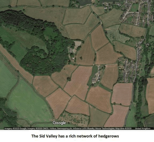
The importance of hedgerows cannot be overstated – especially in these parts:
Hedgerows are important, not just agriculturally for boundaries, crop management, water control and defence. They also have ecological importance, they support wildlife and insects, and can help with climate change and mitigate pollution. The key to a successful hedgerow is management and the plants found within. Hedgerows themselves may not be declining but managed ones are, replaced by remains that may be less useful agriculturally, yet still have biological significance. Hedgerows are a priority habitat and should be protected but they must be kept in good condition, repaired, and maintained
And in these parts, the network of hedgerows are important on so many levels, as recorded in the excellent Sid Valley Hedgescape study from 2020, put together by the Sidmouth Arboretum [with the full report also made available].
There is a fair amount of protection, as detailed by the Devon Hedge Group – but the importance of hedgerows is very much a felt thing. Because people get very attached to hedges: they are very much a treasured part of our heritage, of our landscape, of the view from our window.
Today’s Mail reports on goings on in the West Country, on the fury, as ‘heavy handed’ council workers chop down hedges on the exclusive Sandbanks after complaints overgrown foliage was scratching residents’ expensive cars… but face a backlash for creating an ‘eyesore’
Going beyond the ‘fury’, the Mail today looks at the wonder of hedges which has forged that attachment to these features. Apparently, England’s hedges are long enough to go around the Earth 10 times!
And the Mail tells us that incredible maps reveal the vast network that crosses the English countryside:
They provide a home for birds and insects, keep soils healthy and even help the fight against climate change. Now, due to their importance to the English countryside, scientists have created the most comprehensive maps yet of England’s hedges. The scientists used LiDAR – a technology that emits pulses of light to create 3D images – to identify the hedgerows’ locations and measure their heights.
‘Hedgerows are not only an intrinsic part of England’s rural heritage, they can also be a real asset in helping to tackle the biodiversity and climate crises,’ said project leader Dr Richard Broughton at the UK Centre for Ecology and Hydrology. ‘The new map enables us to see where hedgerows are sparse and identify sites for targeted planting and restoration efforts, linking up habitats and improving the hedgerow network. It can also be used to estimate the potential amount of carbon that hedgerows could remove from the atmosphere and store.’
Looking at the UK Centre for Ecology & Hydrology press release from today, there is a lot more to delve into – including the maps themselves:
To delve deeper into the importance of hedgerows, UKCEH has recorded a podcast as part of its new series Counting the Earth. It includes interviews with Dr Jo Staley and Dr John Redhead of UKCEH, Devon farmer Robert Wolton and hedge-layer Alex Musson. UKCEH’s Land Cover Maps Plus: Hedgerows dataset is available to download from the Environmental Information Data Centre website.
…