Steering Group to meet Tuesday 6th October.
New research on erosion at Sidmouth: “When considering the future it is always helpful to have a view of the things which have happened in the past.”
Newly-available 2017 report “throws up all sorts of questions around the design brief, the project aims & objectives, the modelling and the costings.”
.
The steering group of the Beach Management Plan last met up on 6th February.
This was submitted at the time by the VGS:
Beach Management Plan: reframing the question – Vision Group for Sidmouth
.
The meeting previous to that was on 6th August the year before.
It’s been a long process:
Beach Management Plan: on hold? – Vision Group for Sidmouth
.
It will be meeting again tomorrow, 6th October:
Sidmouth and East Beach Management Plan and Scheme – East Devon
.
Meanwhile, there have been a few updates to the official pages – including all of the FAQs regarding the splash wall on 22nd September and this on 1st October:
.
Interestingly, the heading at the top of the official pages invites us to “Read the 2015 Sidmouth and East Beach Management Plan which outlines the plan for management of Sidmouth’s beaches.”
And yet a document only added last week, on 1st October, provides the final appraisal report from 2017:
Sidmouth & East Beach Management Plan: Options: Appraisal Report
.
This report throws up all sorts of questions around a) the design brief; b) whether the project aims line up with the objectives; c) the modelling; and d) the costings.
And still, many of these questions have not yet been addressed:
Beach Management Plan: Saving Pennington Point – Vision Group for Sidmouth
.
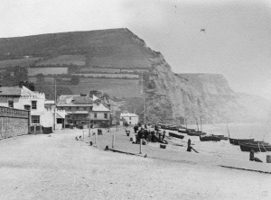
The key concern, then, has been the protection of the cliffs at Pennington Point – which have been providing natural protection for the eastern part of Sidmouth for centuries.
Here is the latest piece of research from the VGS, which gives essential historical context for current plans:
When considering the future it is always helpful to have a view of the things which have happened in the past; we are fortunate that pictures of Sidmouth have been taken since the 1860s and are available to inform us. These images show erosion of the cliffs to the east and how beach levels have varied over time.
Erosion at Sidmouth in pictures – Vision Group for Sidmouth
.
Finally, there is this report from 2011 on the “Natural and artificial influences on coastal erosion at Sidmouth”.
Its author, RW Gallois, seems to have done quite a lot of work with the District Council and he is not convinced by some of the ‘facts’ put forward:
Engineering works in the 19th and 20th centuries that were designed to protect the low-lying parts of the town included the construction of sea walls, and groynes and offshore bunds to protect a ridge of storm-beach gravels that acts as a natural sea defence. These works have collectively had an effect on erosion rates in the cliffs of Triassic sandstone and mudstone on the east side of the town…
It can also be accessed from Dorset Geological Association without creating an account