The projections do not take into account coast and river defences, which are designed to hold back the waters to protect homes and businesses
.
Flooding is an issue in the Sid Valley as much as it is elsewhere:
Flooding issues in Sidmouth: part 2 – Vision Group for Sidmouth
And there is also the issue in these parts of ‘development’ in the wrong place – namely areas that will be increasingly prone to flooding:
Flooding and development in East Devon – Vision Group for Sidmouth
Don’t build on flood plains – Vision Group for Sidmouth
East Devon Local Plan consultation: Sidford industrial estate – Vision Group for Sidmouth
Although there are some clever ways of dealing with it:
Natural Flood Management in East Devon – Vision Group for Sidmouth
Resilient responses to reverse the effects of urban flooding – Vision Group for Sidmouth
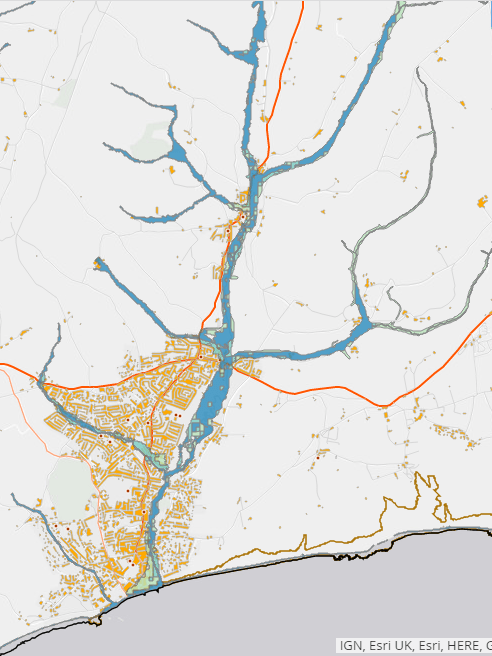
A piece this week on the Devon Live news site looks at the increased risk of flooding:
Devon map shows impact of rising sea level on your homes
As global leaders discuss tackling climate change at the Cop26 summit in Glasgow, a map shows how rising sea levels could change the shape of Devon’s coastlines forever. The map produced by Climate Central using the latest sea level predictions shows the land which would be below the annual flood level in 2050.
The map shows how an expected increase in the sea level of up to 29cm (11 inches) over the next 30 years could see unprotected land underwater from flooding. It shows how the sea could inundate low-lying coastal areas, and the vital importance of defences to protect homes and businesses.
Low-lying areas of the Devon coast are particularly at risk from tidal flooding, and an increase in storms from climate change could also speed up erosion. Changing weather patterns are seeing more rainfall, which increases the flood risk from rivers…
The projections do not take into account coast and river defences, which are designed to hold back the waters to protect homes and businesses. The government is funding a series of schemes across Devon as part of a new £5.2billion six-year programme of investment in flood and coastal defences announced in July to protect the most at-risk properties, doubling the amount spent in the previous six years.
Devon map shows impact of rising sea level on your homes – Devon Live
Climate Central | Land projected to be below annual flood level in 2050
The County has a strategy:
Devon Local Flood Risk Management Strategy 2021-2027 – Flood Risk Management
And Sidmouth, along with other coastal towns, has a beach management plan:
From the BMP Steering Group – Vision Group for Sidmouth
The District Council put together a ‘story map’ on climate change in 2019 – much of which includes flooding – and some of which will impact any beach management plan:
Climate Change in East Devon
The IPCC’s projects that global mean sea level will increase… the increase could be only 30cm by 2100, relative to the 1986-2005 average. If the worst-case scenario occurs, the growth could be as much as 90cm to 1m…This study used the decrease in daily precipitation by 3.5% by 2100. This is not a significant change in precipitation and, as a result, the risk of flooding by rivers and sea is unlikely to be significantly impacted by climate change
The current extent of flooding by rivers and sea, for all probabilities of flooding, covers 73.17km2 of East Devon. This means that 9% of East Devon is at least somewhat vulnerable to flooding. The majority of this flooding will be to grassland
Whereas there might be more significant risk of flooding from the district’s rivers:
(See map)